Eratosthenes’ Vision
![]()
Eratosthenes’ Vision
Eratosthenes of Cyrene (275-194 B.C.) was a Greek scholar who lived and worked in Cyrene and Alexandria. Eratosthenes was director of the famous library in Alexandria, and is known for numerous important contributions to mathematics, geography, and astronomy. In particular, he is remembered for a technique he introduced which enabled him to compute the first reliable determination of the true size of the earth.
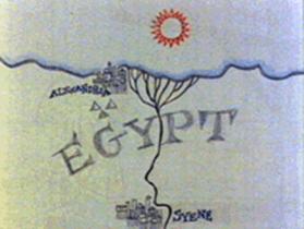
This technique is based on the observation by Eratosthenes that the sun is directly overhead at noon in Syene in southern Egypt on the first day of summer. (This is the time of the summer solstice.) While visiting Syene Eratosthenes apparently stopped at a well and noted that the noon sun reflected directly back from the water in the bottom of the well.
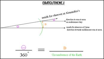
Since Eratosthenes knew that the earth was a sphere, he correctly reasoned that if he could determine the altitude of the noon sun at some other location on the first day of summer, AND if he knew the distance between these two locations, he could compute the circumference of the earth as a simple ratio. This principle is illustrated in the following illustration, along with a sketch of a reconstructed map of the world as known by Eratosthenes.
When Eratosthenes returned to Alexandria, being a good astronomer, he knew he could wait until next year on the first day of summer and measure the altitude of the noon sun. Then since he had kept track of how far he had traveled from Syene to Alexandria, he could determine the circumference and the diameter of the earth.
Now, in reality, Eratosthenes, being a good administrator, probably had assistants measuring the altitude of the noon sun on a regular basis from Alexandria, so he could probably simply consult the records of solar observations from Alexandria. However he actually obtained the data, the difference between the noon sun elevations at Syene and Alexandria on the first day of summer was approximately 7 degrees. Furthermore, Eratosthenes probably did not need to measure the distance between the locations since he had the reliable geographic data accumulated by Alexander The Great.
Here is a diagram the shows the details of the computations. Here theta is the difference in the elevation or altitude of the sun, and D is the distance between the two observing locations. Note that this equation correctly describes the situation even if one of the observing locations does not happen to have the sun at the zenith. We just need to have the difference in the altitude of the sun observed at the same time from two different locations.
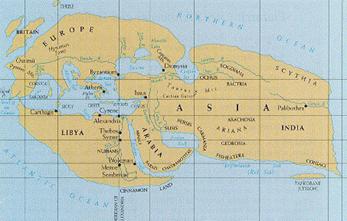
Eratosthenes’ World
Map
While Eratosthenes certainly
prepared numerous maps of the world as it was known by the people of his
time, none have survived. The following illustration is one of the best
available reconstructions of a world map according to Eratosthenes. It is
based on descriptions of the Eratosthenes map as provided by Cleomedes and
Posidonius, both of whom were able to view the original Eratothenes map.
![]()